Severe Thunderstorm Watch vs. Warning: NWS Rules Explained
When the sky turns dark and your phone buzzes with a weather alert, every second counts. Many people confuse a severe thunderstorm watch with a warning. This misunderstanding often leads to either unnecessary panic or dangerous complacency. Knowing the exact difference between these two distinct alerts can save your life.
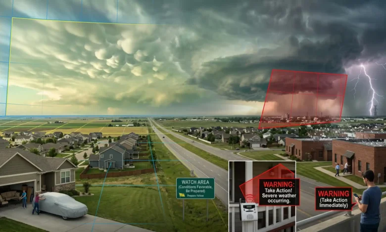
A severe thunderstorm watch means atmospheric conditions are right for dangerous weather to develop over a large area, so you should prepare. A severe thunderstorm warning means a severe storm is actively occurring or imminent in your specific location. When a warning is issued, you must take shelter immediately.
Key Takeaways
- A watch means “be prepared,” while a warning means “take action.”
- The Storm Prediction Center (SPC) issues watches across massive, state-wide areas.
- Local Weather Forecast Offices (WFOs) issue warnings for specific, targeted locations.
- Watches typically last up to six hours, giving you plenty of lead time.
- Warnings usually expire in 30 to 60 minutes because the danger is immediate.
- The National Weather Service officially requires 58 mph winds or 1-inch hail to declare a severe thunderstorm.
Quick Start: Watch vs. Warning Decision Matrix
| Alert Type | Issuing Agency | Meaning | Typical Area Size | Duration | Required Action |
| Watch | Storm Prediction Center | Conditions are favorable | ~25,000 sq. miles | Up to 6 hours | Be prepared, secure items, review plans |
| Warning | Local Forecast Office | Danger is imminent | ~600 sq. miles | 30 to 60 mins | Take shelter in a sturdy building immediately |
What Exactly is a Severe Thunderstorm Watch?
The NWS Definition and Timeline
A Severe Thunderstorm Watch simply means the ingredients for dangerous weather are present. Atmospheric conditions are favorable for severe thunderstorms to develop in and close to the designated watch area. You are not in immediate danger, but the threat is building.
These alerts are issued by the Storm Prediction Center (SPC), located in Norman, Oklahoma. Because the SPC monitors broad national weather patterns, a watch covers a massive geographic footprint. The average watch spans about 25,000 square miles, often covering half a state or crossing multiple state lines.
A watch is designed to give you a long lead time. They are generally valid for a period of about six hours.
Pro Tip: Treat a Severe Thunderstorm Watch as your “readiness phase”—use this time to charge your electronics, secure loose outdoor patio furniture, and check the batteries in your weather radio.
What Does a Severe Thunderstorm Warning Mean?
Imminent Danger and Local Jurisdiction
A Severe Thunderstorm Warning means the threat is no longer just a possibility. A severe thunderstorm is actively occurring, is imminent, or has a very high probability of striking your exact location soon. This poses a direct threat to life and property.
Unlike watches, warnings are highly localized. They are issued by your local NWS Weather Forecast Office (WFO). Instead of blanketing entire states or strict county boundaries, meteorologists draw specific warning polygons on a map to outline the exact path of the storm cell.
These targeted warning areas are small, averaging about 600 square miles. Because the danger is immediate, a warning is only valid for a short window. They typically last between 30 and 60 minutes.
Expert Quote: “Severe Thunderstorm Warning: Take Action! Severe weather has been reported by spotters or indicated by radar.” — National Weather Service, 2026.
Common Mistake: Do not rely on visual confirmation to decide if you need to take shelter during a warning. Severe weather features like tornadoes or damaging winds are often wrapped in heavy rain, making them impossible to see as they approach.
The Official NWS Severe Thunderstorm Criteria
To the general public, any storm with heavy rain and loud thunder might seem severe. However, meteorologists classify storms using strict, objective criteria. The National Weather Service officially defines a severe thunderstorm as a storm that meets at least one of the following physical metrics:
- Damaging Wind Gusts: Winds reaching 58 mph (50 knots) or greater.
- Large Hail: Hail stones measuring 1 inch in diameter or larger.
- Tornadic Activity: The storm produces a tornado.
Winds of 58 mph can easily down tree branches, knock over power lines, and turn unsecured items into dangerous projectiles.
The Updated Hail Threshold
If you read older safety materials, you might see severe hail listed as 3/4 of an inch. The NWS officially updated this threshold to 1 inch—roughly the size of a quarter.
Meteorologists adjusted this baseline because research proved that significant structural and vehicle damage increases sharply once hail reaches the 1-inch mark. Smaller hail, like pea or penny-sized stones, can ruin crops but rarely breaks windows or dents roofing shingles.
What About Lightning and Heavy Rain?
A common misconception is that intense lightning or blinding downpours automatically make a thunderstorm severe. Lightning is present in every single thunderstorm and remains a deadly hazard. However, the frequency of lightning strikes is not a metric used by weather offices to classify a storm’s severity.
A localized storm can bring a spectacular lightning show and minor street flooding without ever triggering an official NWS severe thunderstorm alert.
Mid-Article Summary: Alert Checklist
- Severe Thunderstorm Watch: Issued hours in advance by the national Storm Prediction Center. Covers multiple counties or states. Conditions are favorable; stay alert.
- Severe Thunderstorm Warning: Issued for immediate threats by your local Forecast Office. Covers a small radar polygon. A dangerous storm is happening now; take cover.
- Severe Baseline: Must feature at least 58 mph winds, 1-inch diameter hail, or a tornado. Lightning frequency is not a factor.
Severe Weather Readiness Checklist
When severe weather is in the forecast, timing your response is everything. Use this checklist to protect your home and family based on the current alert level.
Actions to Take During a Watch (Be Prepared)
- Monitor the Forecast: Keep an eye on local radar updates and ensure your phone’s emergency alerts are turned on.
- Secure Your Property: Bring patio chairs, trash cans, and outdoor toys inside. Strong straight-line winds can easily launch these items through windows.
- Protect Vehicles: If you have a garage or carport, park your cars inside to protect them from potential quarter-sized hail.
- Review Safety Plans: Remind your family where your designated safe room is located—ideally an interior room on the lowest floor, away from windows.
Actions to Take During a Warning (Take Action)
- Move Indoors Immediately: Step away from porches, decks, and open areas. Seek shelter inside a sturdy, permanent building.
- Avoid Windows: Go to an interior hallway, closet, or bathroom. Flying debris can easily shatter exterior glass.
- Stay Off Electronics: Unplug expensive appliances and avoid using corded electronics, which can conduct electricity if lightning strikes your home’s wiring.
- Pull Over Safely: If you are driving, pull over to a safe area away from trees and power lines. Remain inside your vehicle with your hazard lights on until the storm cell passes.
A Tale of Two Responses
Consider how a local outdoor community festival might handle these alerts. Four hours before the gates open, the event coordinator sees that the Storm Prediction Center has placed their county under a Severe Thunderstorm Watch. Because a watch means conditions are favorable but not guaranteed, the coordinator keeps the event scheduled but activates a standby plan. Staff members check emergency public address systems and double-check tent stakes.
Two hours later, dark clouds move in and the local NWS Weather Forecast Office issues a Severe Thunderstorm Warning polygon that cuts directly across the festival grounds. Because a warning means danger is imminent, the coordinator immediately halts the live music, uses the PA system to instruct guests to leave the open tents, and directs everyone into the brick community center nearby. Within ten minutes, 60 mph winds sweep through, knocking over lightweight vendor booths, but the attendees are safe inside.
Summary: Your Next Safety Steps
A severe thunderstorm watch tells you that the ingredients for dangerous weather are assembling over a wide region. A severe thunderstorm warning tells you that a specific, high-intensity storm cell is hitting your immediate neighborhood. Do not wait for a warning to look at the sky, and do not let a watch cause you to panic.
To ensure you stay safe during the next severe weather event, take these three immediate steps:
- Verify your alert sources: Ensure your smartphone has Wireless Emergency Alerts (WEA) enabled.
- Buy a backup radio: Purchase a dedicated NOAA Weather Radio equipped with Specific Area Message Encoding (SAME) alerts for your county.
- Clear your yard: Routinely check your property for dead tree branches that could snap during a 58 mph wind event.
FAQs
Is 60 mph wind considered a severe thunderstorm?
Yes. The National Weather Service classifies any thunderstorm that produces wind gusts of 58 mph or greater as a severe thunderstorm.
Does a severe thunderstorm watch mean a tornado is coming?
Not necessarily, but it is possible. Severe thunderstorms can produce tornadoes with very little warning. If conditions are highly unstable, weather offices may issue a combined watch or transition to a tornado warning.
How long does a severe thunderstorm watch usually last?
A watch is a long-term alert designed to give you time to prepare. It typically lasts for about six hours and covers a broad multi-county or multi-state region.
Can I go outside during a severe thunderstorm watch?
Yes, you can continue normal indoor and outdoor activities during a watch, but you should stay close to a sturdy shelter and keep a close eye on changing radar conditions.
Who issues a severe thunderstorm warning?
Severe thunderstorm warnings are issued by your local NWS Weather Forecast Office. Local meteorologists track specific storm cells via Doppler radar and draw targeted warning boundaries.
What size hail triggers a severe warning?
The NWS triggers a severe thunderstorm warning when hail reaches 1 inch in diameter or larger. This is roughly the size of a standard U.S. quarter.
Is a watch or warning worse?
A warning is more urgent. A watch means severe weather is possible over the next several hours, while a warning means dangerous weather is happening right now and requires immediate protective action.
References
- Federal Aviation Administration, 2013
- National Weather Service, 2026
- Storm Prediction Center, 2008